


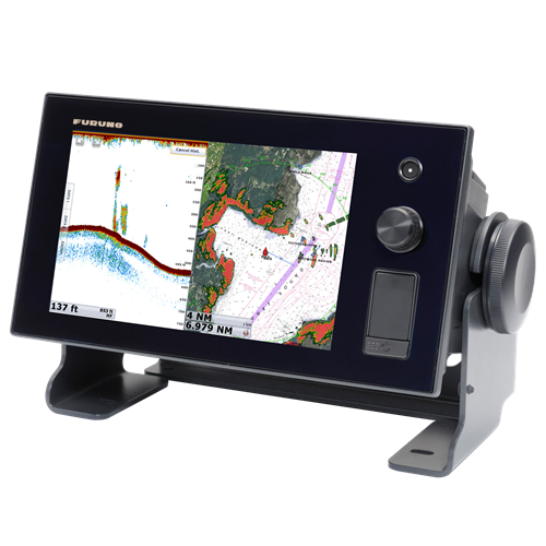
NavNet TZtouch 9" Multi Function Display TZT9
Today's NavNet has come a long way from the first multi function display. Take one look and you will see just how far. A generous 9" or 14.1" display with edge-to-edge glass makes for a clean and stylish installation. The LED backlighting pushes light through every pixel on the screen for remarkable brightness. Anti-reflective glass coating is visible under any lighting condition. Configure the displays with a wide variety of sensors to build a navigation suite that meets your individual requirements. With the NavNet TZtouch TZTBB, the display unit is selectable from virtually any size of wide or non-wide monitor supporting multi touch controls.
FEATURES:
-
Nothing is faster than TimeZero
NavNet TZtouch’s TimeZero™ technology delivers chart processing like you’ve never seen before – seamless chart handling, zooming and panning without the screen disappearing. TimeZero™ technology redefines the meaning of stress-free operation by smoothing out your chart handling actions.
-
Multi-Touch control at your fingertips
Furuno elevates marine touch screen technology to an entirely new level with the industry's first multi touch MFD. The use of multi touch technology opens the door to a wide variety of gesture-based commands. NavNet TZtouch's waterproof display is also ruggedized to perform perfectly in wet, harsh conditions.
-
Pinch to zoom and other intuitive gestures
Be more hands-on with our easy-to-understand touch screen interface. TZtouch brings you pinch-to-zoom capability, as well as other multi touch gestures for the most intuitive navigation experience. You'll have full control of each component connected to the network right at your fingertips. Navigation is simplified by using your fingers to zoom and pan around the chart. As soon as your fingers touch the display, taps, pinches and swipes are instantly transformed into action. You will learn your controls so quickly that you'll be up and running in no time. To make operation even easier while underway, adjustments such as range and gain are easily made from either the on-screen touch menu or our patented RotoKey™.
-
Remotely view and control your bridge with apps from your smartphone and tablet
Engineered to utilize the latest technology, NavNet TZtouch opens the door to cutting edge WiFi features, such as tablet and smartphone apps, points of interest (POI), real time weather data, software updates and more. Take full control of your NavNet in a whole new way.
-
Satellite PhotoFusion™ offers a birds-eye view without obstruction of critical data
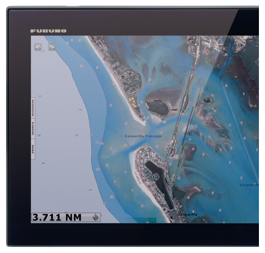
you can load any two ultra-wide high-resolution satellite photo areas at your convenience. Land areas (zero depth) are completely opaque, so these areas are displayed as high-resolution satellite photos on the chart. As the depth increases, the satellite photography becomes more transparent. This allows you to see where the shallows end and the deeper water begins, while still allowing the raster or vector chart to be visible.
-
Free & easy-to-use marine weather forecasts
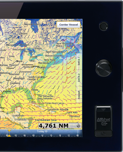
The weather tool is completely free and easy to use, giving you unlimited access to weather forecasts worldwide 24 hours a day provided by NavCenter. Select geographic coverage, data type, period of time, and then choose how to receive the file. NavNet TZtouch provides up to 16 days of weather forecasting.
SPECIFICATIONS:
DISPLAY UNIT |
|
| Type | Color TFT multi touch LCD |
| Screen Size | 9" wide |
| Screen Resolution | WVGA 800 x 480 |
| Screen Brightness | 900 cd/m2 (typical) |
| Language | Chinese (simplified Chinese chracters), Danish, English (US & UK), Finnish, French, German, Greek, Italian, Japanese, Norwegian, Portuguese, Russian, Spanish, Swedish |
CHART PLOTTER |
|
| Cartography | MapMedia mm3d chart (C-MAP/Navionics/NOAA) |
| Memory Capacity | 30,000 user points |
| Alarms | Anchor Watch, XTE, Proximity, Depth, Temperature, Speed, etc. |
RADAR |
|
| Display Modes | Head-up, North-up* *Heading input required. |
| Echo Trail | Interval: 15 s, 30 s, 1 min, 3 mins, 6 mins, 15 mins, 30 mins and continuous |
| Target Tracking | 30 Targets* *Heading input required. |
INTERFACE |
|
| CAN bus | 1 Port |
| LAN | 1 Port (100 BASE-TX) |
| USB | 1 Port (USB2.0) |
| Video Output | 1 Port (DVI-D) |
| Video Input | 2 Ports (NTSC/PAL) |
| SD Card Slot | 2 Slots (SDXC card - supports upto 128GB) |
ENVIRONMENT |
|
| Temperature | (IEC60945) -15°C to + 55°C |
| Waterproofing | IP56 (with connector cover), IP22 (with connector boot) |
POWER |
|
| Power Supply | 12-24 VDC |
| Power Consumption | 42 W (3.5 A - 1.8 A) |
Share:
Related Products

 GPS OR WAAS CHART PLOTTER with built-in CHIRP FISH FINDER GP-1871F
7" GPS Chart Plotter/Fish Finder with Tablet Control/Mirroring function Availabl...


