


GPS NAVIGATOR 4.2" GP-39
The FURUNO GPS navigator GP-39 provides accurate and reliable position fixing, thanks to a 12-channel GPS receiver combined with integrated SBAS (WAAS/EGNOS/MSAS) technology.
The GP-39 has various display modes (Plotter, Highway, Steering, NAV data, Satellite monitor and 2 user customizable modes) on the 4.2" color LCD. Up to 3,000 points of ship track, 10,000 waypoints and 100 routes (each with up to 30 waypoints) can be stored. The waypoint and route data can be exported/imported via a USB flash drive or signal converter.
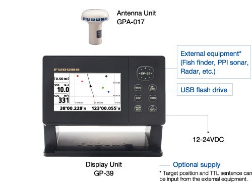
The GP-39 can be networked with a fish finder, sonar, radar or other navigation equipment for feeding highly accurate navigation data.
FEATURES:
-
Newly designed GPS core delivers enhanced position fixing accuracy
-
4.2" high-resolution color LCD
-
Storage for 3,000 track points, 10,000 waypoints and 100 routes
-
SBAS capable for better positioning calculations
-
Share and display position information on networked equipment such as a fish finder, sonar, radar, etc.
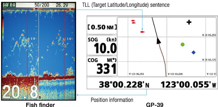
The GP-39 delivers the position information to an interfaced fish finder or sonar. Also, the GP-39 receives the TLL (Target Latitude/Longitude) sentence from networked fish finders or sonars and can display the received information. This allows you to mark fish school locations easily.
-
7 display modes available, including 2 user-customizable modes
-
Waypoint and route data can be exported/imported via a USB flash drive or signal converter
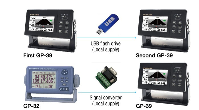
Waypoint, route data and setting information can be exported/imported via a USB ash drive between GP-39 units. The waypoint and route data in GP-32 can be transferred to GP-39 by means of signal converter. You can backup information, or share useful information between vessels.
SPECIFICATIONS:
Display Unit |
|
| Screen Type | 4.2" Color LCD |
| Screen Resolution | 480 (V) x 272 (H) pixels |
| GPS Antenna | External |
| Display Modes | Plotter, Highway, Steering, NAV Data, Satellite monitor, User Display (Digital, Speedometer, COG) |
| Language | English, French, Spanish, Chinese, Vietnamese, Malay, Indonesian, Thai |
GPS / SBAS (WAAS/EGNOS/MSAS) |
|
| Receiving Type | GPS: 12 channels parallel, 12 satellites tracking, C/A code, all-in-view |
| Receiving Frequency | L1 (1575.42 MHz ± 1.023 MHz) |
| Accuracy | GPS: 10 m (95% of the time, HDOP≤4) |
PLOTTER |
|
| Memory Capacity | 3,000 ship's track points |
OTHERS |
|
| Waterproofing | Display unit: IP55 |
|
Power Supply |
12-24 VDC : 0.7-0.3 A |
| Weight | 0.39 kg 0.86 lb (Bracket mount) |
Equipment List
- Display unit GP-39
- Antenna unit GPA-017 with cable 10 m
- Plastic bag
- Standard spare parts and installation materials
Interconnection Diagram
Share:
Related Products

 GPS OR WAAS CHART PLOTTER with built-in CHIRP FISH FINDER GP-1871F
7" GPS Chart Plotter/Fish Finder with Tablet Control/Mirroring function Availabl...


