GPS-WAAS COLOR CHART PLOTTER with FISH FINDER GP-3700F
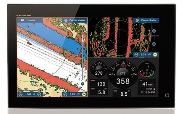
The GP-3700F is the new high performance color GPS/WAAS Chart Plotter/ Fish Finder combination unit. The GP-3700F incorporates easy-to-use interface from the GP-3500, while adding new enhancements and features. With a variety of innovative functions, short-cut control keys and a 12.1-inch IPS screen that provides clear visibility, the GP-3700F lets you immediately grasp a situation surrounding your vessel. Large storage capacity for track points, buoy points and marks/lines makes it a perfect solution for long term fishing operations.
FEATURES:
-
User customizable keys
User customizable keys are designed to create short-cuts to menus. Customize menus before you leave the dock for faster, effortless and more intuitive operation on the sea.
-
12.1 inch large display
The larger IPS LCD screen, which features a distinctively clear and wider viewing angle, gives you excellent readability in changing sea conditions.
-
Huge storage capacity
The GP-3700 series is capable of storing up to: 30,000 own ship track points, 10,000 TT/AIS/consort/GPS buoy points, 30,000 mark/lines, and can record way points and routes.
-
A variety of display modes
The GP-3700 series provides and displays navigation data in a wide variety of modes. All the
display modes can be switched by tapping “DISP” key according to your favor.
-
UNDO/REDO functions
The "UNDO" key lets you go back one operational step of deleting and drafting your marks and lines with a single press of a key. While the "UNDO" key works as going back your operation, the "REDO" function recovers your last operation.
-
Easy-access USB port
USB flash drive (local supply) can be connected to the front panel. Stored data can be used for retrofit, review for the service, and record of your navigation marks.
-
ACCU-FISH™ - A unique fish size analyzer based on the latest digital technology
-
Bottom Discrimination - Analyze bottom structure
Provides an at-a glance recognition of bottom composition with four types of graphical displays (Rocks/Sand/Gravel/Mud) when connected to a supported thru-hull or transom mount transducer.
SPECIFICATIONS:
Display Unit |
|
| Screen Type | 12.1-inch IPS color LCD |
| Screen Resolution | 600 (H) x 800 (V), SVGA |
| Display Modes | Plotter, Compass, Satellite information |
GPS / SBAS (WAAS/EGNOS/MSAS) |
|
| Receiving Type | GPS: 12 channels, 12 satellites, parallel tracking |
| Receiving Frequency | 1575.42 MHz |
| Accuracy | GPS: not exceeding 10 m, (2drms, HDOP 4) DGPS: not exceeding 5 m, (2 drms) optional kit required SBAS: not exceeding 7 m, (2 drms |
PLOTTER |
|
| Chart | MapMedia Vector Chart |
| Memory Capacity | 990,000 points (recording memory 1 block + storage 10 block) |
FISH FINDER |
|
| Frequency | 50/200 kHz |
| Transmission | 600 W or 1kW |
| Display Range | Range5500 m Shift01,200 m |
OTHERS |
|
| Waterproofing | Antenna unit:IP56 |
| Power Supply | 12-24 VDC, 2.5-1.3 A |
| Size | 351 (H) x 339 (W) x 179 (D) |
| Weight | 4.8 kg |
Equipment List
- Display Unit GP-3700-E
- Antenna Unit GP-020S
- Antenna Cable 15m
- Installation Materials and Standard Spare parts
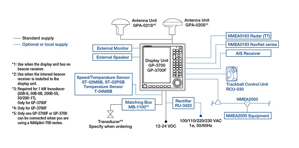
Interconnection Diagram

Share:
Related Products
 Simplified Voyage Data Recorder (S-VDR) VR-7000S and VR7000 VDR
Records all crucial data to help identify the cause of marine accidents


