


BUOY SV-1800A TYPE
The satellite buoy (Marinestar) is a new buoy positioning and tracking information system that can display the position of the buoy in an electronic chart by the pinpoint, and promote the efficiency improvement of the fishery. The buoy position and tracking information of buoy flows and is displayed in the chart. Because the speed where the buoy flows and the surface water temperature in addition to the direction are displayed, it is possible to use it as current information.
FEATURES:
-
You can suppose quantity of schooling fish
-
Since the number of Schooling fish information data can be displayed, the transition of Schooling fish volume is obvious.
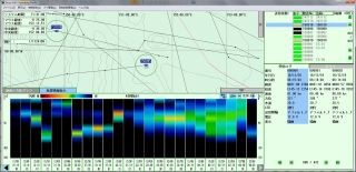
Ship station: Example of display of buoy and Schooling fish information on chart
-
It is possible to share location information and schooling fish information with fishing vessels.
-
It will automatically transmit Scholling fish data every day to the sunrise time of the buoy's waters(Every hour Total of 24 times schooling fish data sent at Sunrise time).
-
You can check the school fish information in the best condition to see with the GAIN (sensitivity) adjustment function.
-
The buoy response time is greatly shortened (compared to our former model buoy).
SPECIFICATIONS:
| Diameter | Approx. 420 mm |
| Height | Approx. 290 mm |
| Weight | Approx 9.2 kg |
| Main Material | Resin |
| Communication Method | Immarsat Satellite |
| Area | Global |
| Data Transfer Speed | (Transmission) 10 bps (Reception) 9 bps |
| Sensor Range | 32-122F, 0-50C (0.1 step) |
| Power Source | Solar Panel and Battery 12V 12Ah 3W External Charger |
| Waterproof | Approx. 5 m (0.5 BAR) |
Composition Equipment
| Bouy | SV-6000ES model Echo Sounder Satellite buoy |
| Ship station | SV-SC5000 model complete set (PC, buoy management chart with software) |
Echo Sounder Function
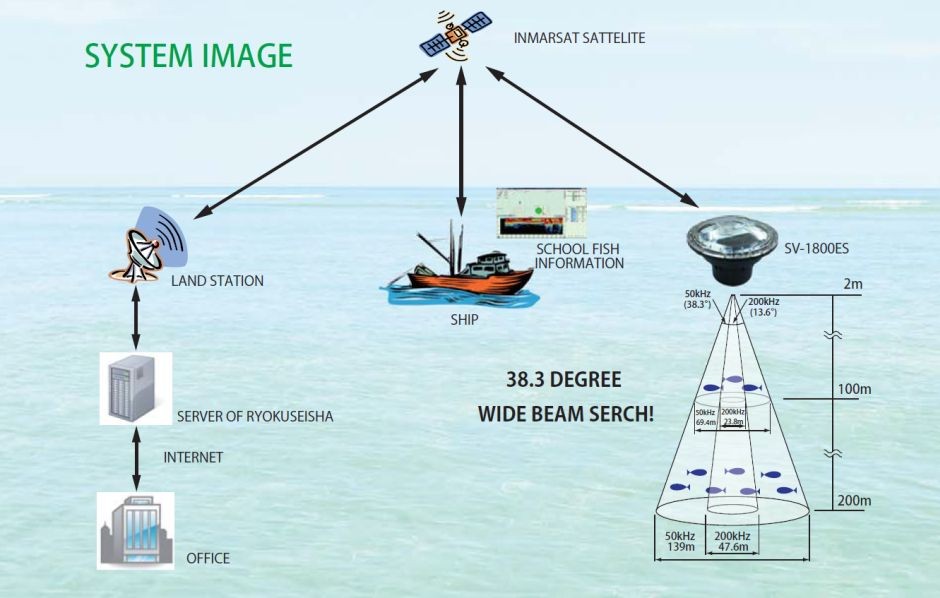
Since it transmits and receives using satellite communication, buoy information can be reliably obtained Information on buoys and operation commands from ship stations are communicated via Inmarsat satellite → ground station → Inmarsat satellite. It will automatically transmit fish school data every day to the sunrise time of the buoy's waters.
Every hour Total of 24 times schooling fish data sent at Sunrise time.
The transmission interval of the buoy can also be changed by sending a command.
You can know the information of the school of fish around the buoy and become easy to make an operation plan, and fuel costs or charges for fishing in another's territory lead to reduction of the cost.
Share:
